
![]()
This is it! The day has arrived. We are taking on The Whole Enchilada! If you know anything about mountain biking in Moab, you know about The Whole Enchilada. There are many, many trails in Moab, with very technical black diamonds and cliff edge trails that get gnarly. This one offers just that and more. Combine the desert oasis of riding on sandstone and slickrock that Moab is known for with also alpine riding in the La Sal mountains. Reach an elevation of 11,200ft where you’ll be offered pristine mountain views, aspen forests, ripping along singletrack trails with leaf littered dark humus soil, to moving fast on dirt jeep roads and the red rock of the desert. You might be slowed down a few times riding through a bit of sand but just like that, you regain your speed hitting rock drop-offs that feel like it will never end only to finish on a local paved bike path that takes you on into town. It’s an adventure in mindfulness. You’ll be challenged, but will be in the present, hopefully enjoying every moment. If you don’t crash.

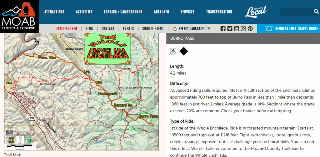
To break it down, The Whole Enchilada can be looked at as a trail system composed of six different trails. Or even more than that if you want to separate the climb through Geyser Pass and also the very end along the bike path, waiting for the wall of rock that seems endless to open up to start the turn toward town.
It’s no joke of a ride. You need to know what you’re doing. And be prepared with water. PLENTY OF WATER! Dan and I carried 4L per person, 8L total and used every drop! Electrolytes are a necessity as well, sodium and potassium along with the water to keep you hydrated while moving. We packed four energy cube packs containing six chewable cubes each, so 12 per person. Depending on how fast you ride, if you’re going to stop for photos (a must for me) and if you’re able to eat on a ride like this (I cannot. Gels and cubes are it. With water.) It will take on average about six to seven hours. Some can finish it in less, maybe 5 hours or less but they’re moving and not stopping to appreciate or capture the scenic environment. We passed a few who were stopped and picnicking with full lunches.
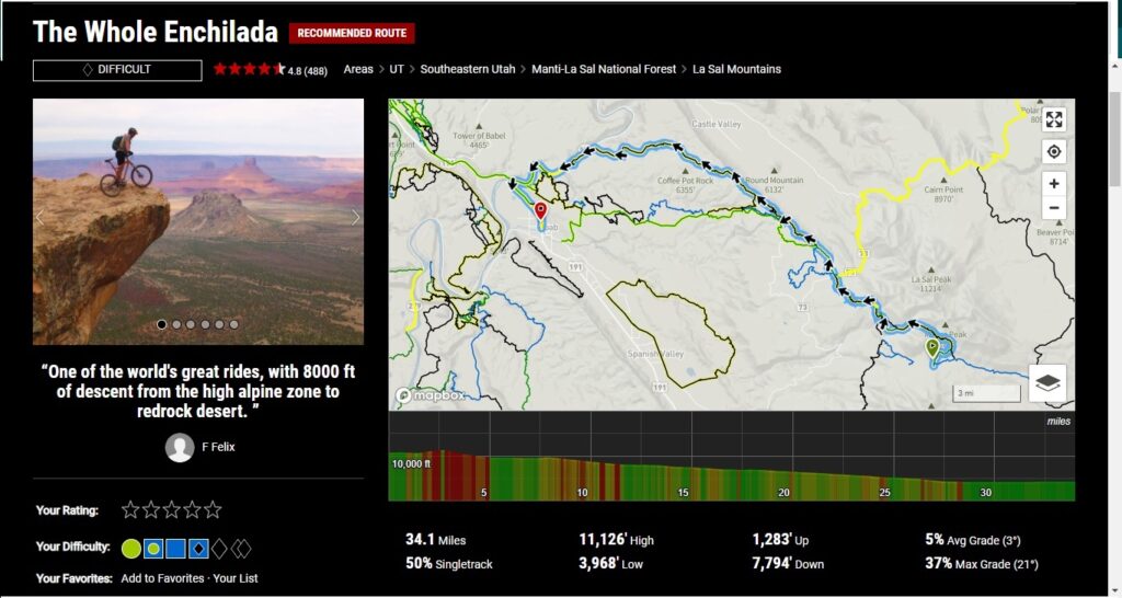
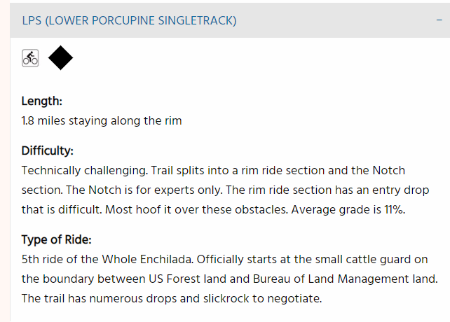
Above and below you can see the grading of difficulty depending on which trail. The map above says 11,126′ at it’s peak but my Garmin clocked me at 11,200′ You’ve got some blue level sections mixed in but overall it is black diamond rated difficult.

Burrow Pass at the very beginning is fast, steep and downhill mountain riding. I went over my handlebars. Twice. It’s black diamond for sure and something a full face helmet would usually be required, but that’d be the only area where it’s as steep. Porcupine Rim at the very end is everything that challenges my anxiety. Technical along rim drop-offs with views of the Colorado River under intense sunshine and desert heat. That part, that comes at the very end as you’re peaking in exhaustion, it the most challenging if you ask me. Intense riders and locals love this section.

So let’s get going. Early rise at the Sunflower Inn, I was nervous and could barely eat. What I mistakenly did was google “The Whole Enchilada dangerous”. I should have just went with it, but instead I psyched myself out. Our Breakfast To-Go was perfect, but I just picked at the fruit and had the coffee.
![]()
Our stay at the Sunflower Inn was perfect. A barn to store out mountain bikes, load them up early morning walking along the wildflowers on site.


Bikes loaded, ready to make the trip up the mountains. My concern was mostly that the trail would get too close to the rim edge. I wasn’t really thinking I would actually go over (ok, maybe I visualized that once) but more so that it would be so close to the edge that I wouldn’t be able to continue forward and get out of the trail. My confidence wanes with heights. Now, had I not googled the photos and the fact the trail runs along the rim, I would have been fine. The places it is close to the edge, it’s an easy trail itself and far enough away that at the speed I ride, if I bit it, I would just slide on the trail. Not over the edge to my death.
![]()
Plenty of bikers ready to take the morning shuttle.

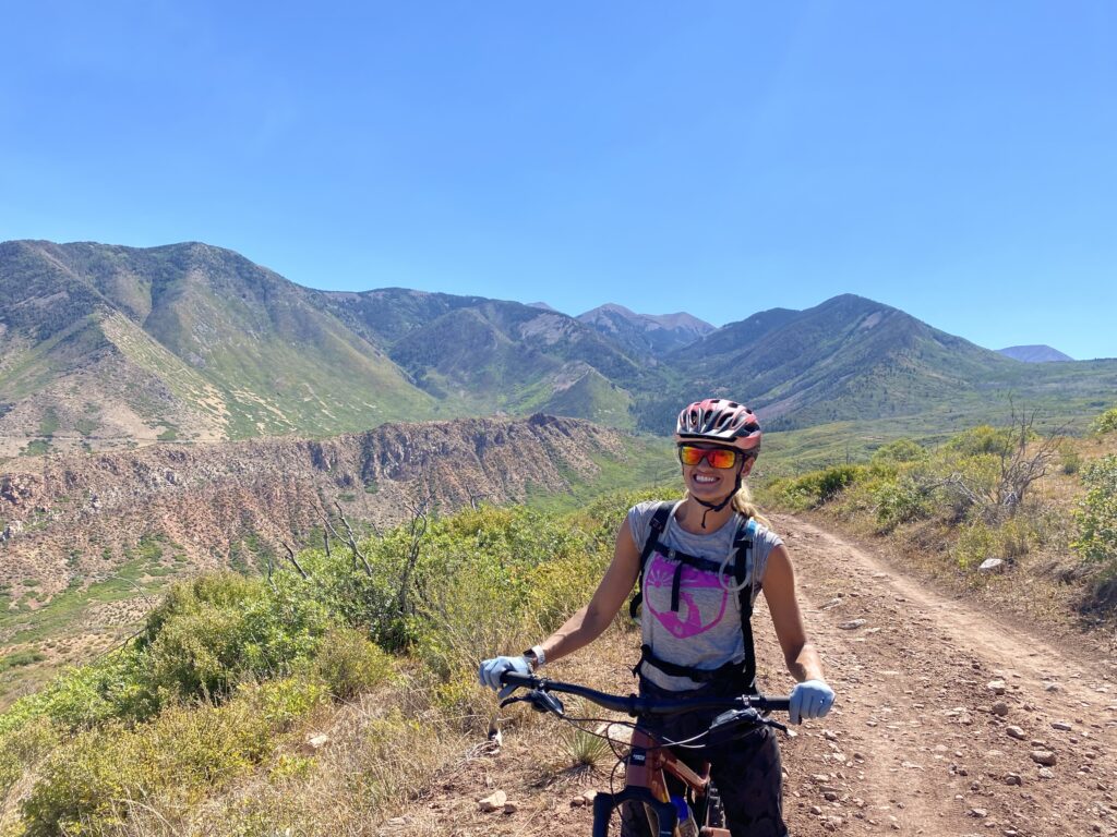
Dropped off at Geyser Pass, get on the bike and get ready to climb! The is the Alpine forest and it can be snow-covered in early Spring and even Fall. This day for us was perfect. Sunny and cool in the 50s.
![]()
![]()
![]()
![]() Once you climb to the top, it’s time to ride! This is the most downhill section of trail as you drop in from Burro Pass. It’s narrow with tight switchbacks. The grade is steep at about 14% at some parts and it is technical with rocks and roots. But it’s also AWESOME! A mountain forest with stream crossings and log bridges. I loved it. Even though I did crash I got back up and kept going with a big smile!
Once you climb to the top, it’s time to ride! This is the most downhill section of trail as you drop in from Burro Pass. It’s narrow with tight switchbacks. The grade is steep at about 14% at some parts and it is technical with rocks and roots. But it’s also AWESOME! A mountain forest with stream crossings and log bridges. I loved it. Even though I did crash I got back up and kept going with a big smile!
![]()
Towards the end of Burrow Pass you’ll glide through an Aspen forest. It’s heaven! Here a cow walked right onto the trail and then moved out of the way for Dan to keep moving forward. This is where you can take a small trail to Warner Lake and take in an incredible view of a evergreen mountain lake while on your trip in the desert.
![]()
![]()
We were riding along with another group of people at the beginning but began to go on our own once we moved on from Warner Lake. Hazard County Trail is next and I took no photos of this as the trail was AMAZING! So flowy, so fun, so perfect. From there it’s Kokopelli trail.
![]()
One of my favorites shots from the ride, this is the view from Kokopelli but Dan is taking the pic and the view of what is behind us. We came from the other side of those mountains, ripping through them in amazement! And now we are continuing into more of what Moab is known for, slickrock and desert heat. I can feel it now, the sun is shining and it is much warmer but still so incredible. Kokopelli is a jeep road so it felt like just a ride to connect trails, although still challenging. Water is still plentiful thankfully and we’ve taken some energy gels. Feeling good. It’s about to get lit.
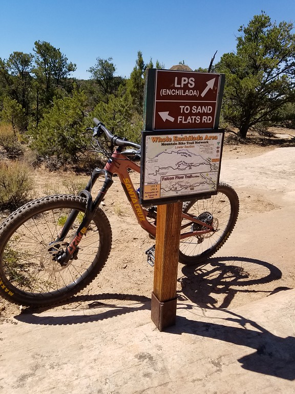
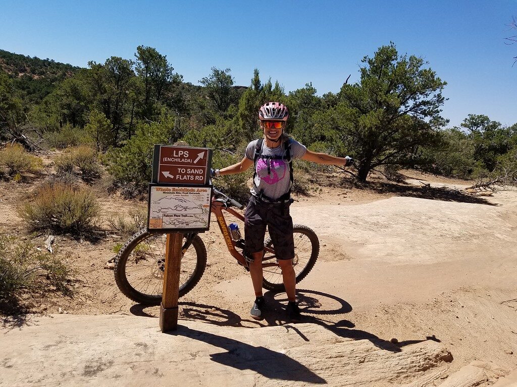
The day prior when we picked up our bikes from Moab Cyclery, the guy working suggested we bail from doing LPS and then also the very intense Porcupine Rim. Maybe he thought I or both of us wouldn’t be able to handle The Whole Enchilada but what’s the point of bailing now? We came to the sign where you have a choice. Keep going on to LPS or take Sand Flats Rd which will veer you off from the most challenging parts of the trail. Nope. We’re staying on the Whole Enchilada and following the sign to LPS.
![]()
![]()
![]()
UPS has some climbing to it, but also drops and then connects to the very technical to me LPS. You’ve got nice fun swooping turns but then also ledges to drop off of and there are some areas of slickrock within some cool Juniper forests. You can see, the view of Castle Valley is incredible from here.
By now, we were running low on water, gulps every now and then. It was super hot, I was still feeling ok but feeling the exhaustion in my arms. My watch died and so did my phone! I did not have both charged as much as I should have. We stopped to take a break but that only proved our need to want to drink more so we got moving. Below are the last few photos I took before hitting what was left of LPS and finally reaching Porcupine Rim.
![]()
Riding Porcupine Rim was daunting. I could see the cliff edge at every turn. It was rock jumps and drops and technical, at what seemed, every turn. My arms were fatigued, I wanted to chug my water but made sure to conserve it and just was feeling the heat. What was most challenged though was my mental toughness. I had to be alert and aware at every move. I didn’t want to crash or get hurt and Dan was way ahead of me wanting to get out of the trail to find water. He was down to just drops.

Porcupine Rim, considered the 4th most Dangerous Mountain Biking Trail in the world by RedBull. Some very fast and edgy parts right along the rim before it takes a turn inwards get you down off the mesa but you also descend through some cliffs towards and along the Colorado River. For me, the drops off the rock ledges and being along the rim was scary. And the fact that I knew it had been rated highly dangerous. Too much information. I should have just went with it without knowing too much.
Below my Garmin Connect recorded information. You can see where it died, right before finishing the Porcupine Rim. Already 26 miles, we still have Porcupine Rim and then five more miles along the bike path to get into town, totaling the ride at 34 miles or just over. Look at the calories burned already. I was depleted to say the least with about 10 more strenuous miles to go.

Finally we go through a circular tunnel under the road and reach the river. We were out! We first began looking for some water to fill our packs. It was soooo hot! And I was mentally exhausted. No water hook-ups at the campsites along the river (I knew this would be the case, I could tell just by looking from a distance) and the river itself was down a pretty steep drop-off from the camps, we couldn’t just jump in to cool down. Probably would have gotten swept away if we did. We went back across the street to a parking lot where a girl hiking with her dog came out and we asked if she knew how far it was to town and if there were any water hook-ups available. She said “If you just did the Whole Enchilada, going into town is nothing. It’s a bike path trail, keep going that way and then turn left towards town. There is a creek right here to cool down in.” And that’s what we did, I walked right in it, scooping the water into my hands, pouring it over my arms and legs. That’s all I needed, I just needed to cool myself down. I didn’t want to faint from heat exhaustion which was what I felt might happen. I wasn’t thirsty (I was but my body wasn’t registering it) I just felt so depleted. We hopped back onto our bikes and began our ride to town. Onwards, we were ready to get back to town and to our truck. Where we parked it earlier that day but felt like so long ago. The bike path along a the cliff wall seemed to go on forever. It will lead you back to town but before you make that left turn, there is a natural spring coming out the red rock. The water is flowing out, you probably will see others filling their containers.
View this post on Instagram
We did it! We got back to our truck, stopped to pick up hydration and I said to Dan “I need about 10 gatorades. And a therapist.” So very Well-Fit, we stayed for the most part Well-Hydrated until those last moments at the end. Is was a Well-Enjoyed Well-Planned Well-Endured Well-Defined adventure! We brought our appetite to Moab and ordered the Whole Enchilada! For Our Whole Well-Being!